01ANX26-01
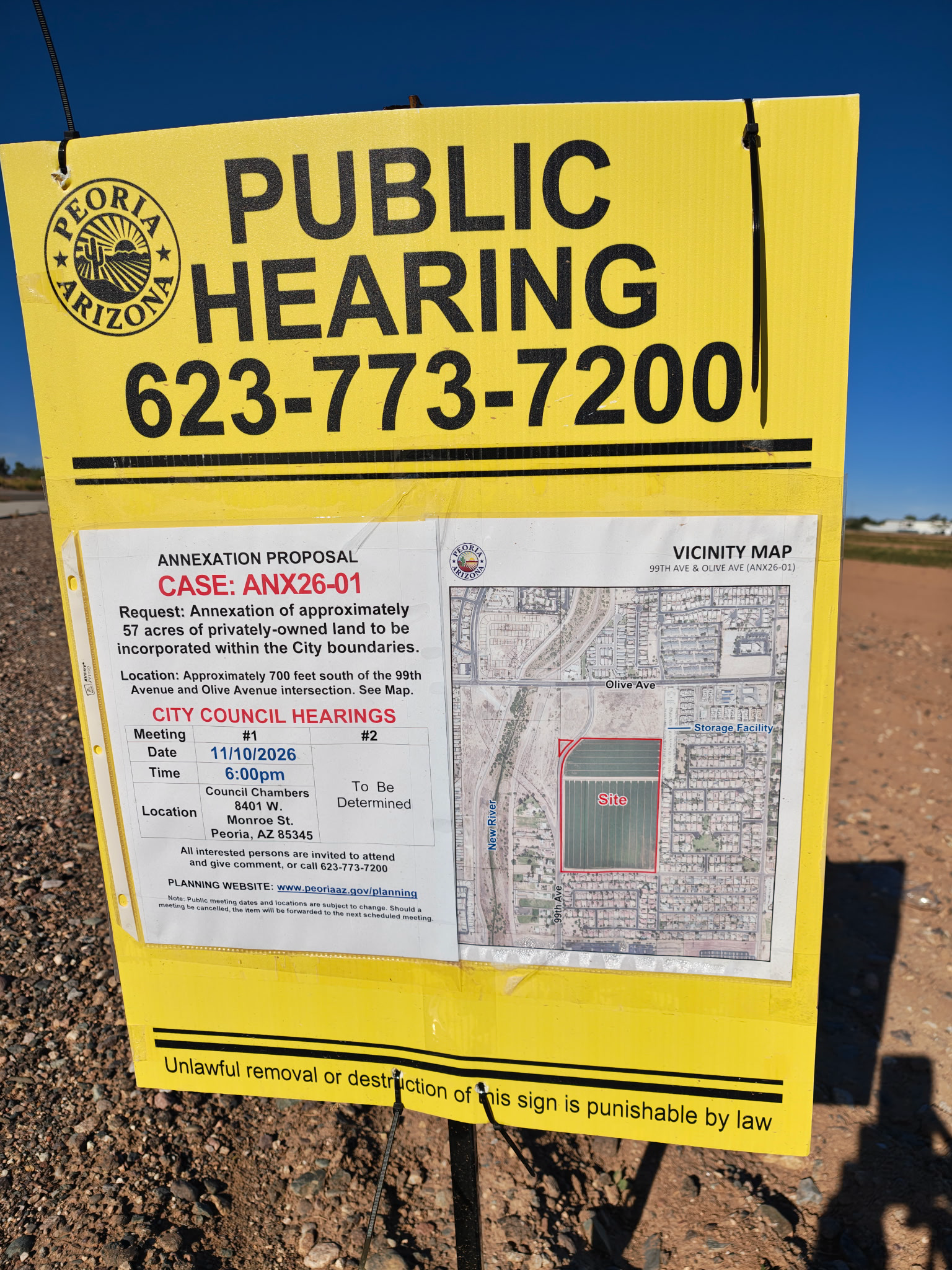
Bring county land into Peoria
Annex 57.2 acres from Maricopa County. The city’s October 6 report identifies the existing county zoning as Rural-43 (RU-43).
Read the annexation record ↗99th Avenue · South of Olive · Peoria, Arizona
A yellow annexation sign is only part of the story. City records link it to a proposal for up to 300 single-family lots and a change to the future of 99th Avenue.
Our position: oppose the proposal as currently documented. Ask Peoria to withhold final approval until traffic, neighborhood compatibility, and infrastructure concerns are publicly addressed.
Independent resident advocacy · Research checked October 31, 2026
Proposed, not approved. Facts, questions, and advocacy are labeled separately.
01 / Follow the case numbers
The sign concerns a city-boundary change. The linked files reveal the housing proposal and a circulation-map amendment. These are separate decisions with separate review steps.
Annex 57.2 acres from Maricopa County. The city’s October 6 report identifies the existing county zoning as Rural-43 (RU-43).
Read the annexation record ↗Change the 57.2 acres from county RU-43 to Peoria Suburban Ranch 43 (SR-43). This initial zoning is distinct from the proposed 300-lot PAD.
Read the initial-zoning record ↗Rezone 66.3 acres to a Planned Area Development (PAD). The public case description states SR-43 to PAD. A PAD establishes project-specific land-use and development standards.
Read the residential rezoning record ↗Remove the future 99th Avenue New River crossing alignment from the Circulation Map and reclassify 99th Avenue between Butler Drive and Olive Avenue from collector to arterial.
This describes a proposed map change. It does not establish a lane count, road width, construction date, or approved road project.
Read the circulation amendment ↗Statuses are a snapshot of public records checked October 31, 2026, not a live feed. The 57.2-acre annexation and 66.3-acre rezoning are different areas; request the legal maps before drawing conclusions about individual properties.
The road question matters
The housing and circulation requests should be evaluated together. Removing a future crossing and changing a street classification could alter how traffic is distributed. The public deserves an understandable comparison of the alternatives.
What we’re asking the city to demonstrate ↓Future New River crossing alignment
Proposed for removal
Concept diagram only · Not a geographic map or road design
Source: GPA26-06 case description
02 / A case grounded in the rules
Peoria’s PAD approval criteria require objective support for roads, neighborhood compatibility, public facilities, and fiscal soundness. Our request: do not make those findings without the supporting record. § 21-605 ↗
Confirmed proposal + unresolved questions
Up to 300 lots and the circulation amendment warrant a combined traffic assessment. The public processing history lists the September 10 traffic-impact review as “Denied”; the underlying comments were not available in this review.
The traffic study, review comments and responses, peak-hour turning counts, intersection queues, emergency access, walking and cycling routes, and a comparison with and without the proposed crossing removal. Explain any effects on Echo Lane and surrounding local streets.
No approval before traffic corrections and required improvements are explained publicly.
Case record ↗Design details not yet verified
The published lot maximum alone does not show how development would meet neighboring homes. Heights, setbacks, grading, lot sizes, lighting, and perimeter landscaping determine day-to-day impacts.
The PAD standards, concept plan and boundary cross-sections showing proposed homes against existing homes. Compare a lower-lot-count layout and stronger perimeter buffers. Identify every requested departure from ordinary development standards.
Require measurable protections for privacy, lighting, and the neighborhood edge.
PAD compatibility criteria ↗Capacity and funding questions
New homes need water, sewer, fire access, school capacity, and maintained streets. The public history lists engineering and school-district reviews as “Denied” in September; this does not reveal the reason or prove a capacity shortfall.
Agency comments and written responses, demand and capacity analyses, the Cost Impact Analysis, improvement schedules, and who pays for each required improvement. Tie necessary work to enforceable development milestones.
Show the capacity, the funding, and the delivery schedule before granting the PAD.
PAD facilities and fiscal criteria ↗Potential impacts to evaluate
The notice places the site near New River. That proximity calls for site-specific drainage review; it does not, by itself, establish that the property is in a floodplain or that neighboring homes will flood.
Grading and drainage reports, floodplain determinations, outfall and retention plans, construction access, dust controls, working hours, and a named complaint contact. Show how runoff and construction traffic will be kept from burdening adjacent properties.
Put mitigation and enforcement responsibilities in writing.
Notice and location ↗03 / Keep the argument credible
The linked Z26-10 description is for up to 300 single-family residential lots. We found no support for describing this case as apartments, a warehouse, or a data center. Other projects in the broader area have different case numbers.
No. Arizona’s annexation statute separates initial zoning from subsequent rezoning. Section 9-471(N) limits initial zoning to densities and uses no greater than the prior county permissions; later zoning changes follow the city’s rezoning process. The 300-lot request is Z26-10. Read the statute ↗
No. Dividing 300 by 66.3 produces about 4.52 lots per gross acre; that calculation is not an approved density or a net buildable-area analysis. Compatibility depends on the actual plan and applicable standards. The stronger objection identifies missing evidence and specific impacts, rather than relying on the number alone.
The city’s GIS record identifies Withey Morris Baugh PLC as the applicant organization and Terri Hogan as the staff contact. An applicant or representative is not necessarily the builder or landowner. The builder and current ownership were not confirmed in this review. Official GIS case entry ↗
That cannot be promised. Annexation decides jurisdiction, and existing county entitlements may still matter. Ask staff to compare what could occur under current county rules with the requested city PAD. Opposing annexation is a policy position, not a guarantee of permanent open space.
No. The sign and linked Peoria cases locate this proposal south of Olive. Do not import Riverwalk’s north-of-Olive approvals, developer, or age-restriction history into this case.
The current narrative and concept plan, detailed PAD standards, traffic study and correction letters, agency responses, grading/drainage analysis, utility capacity and cost documentation, full ownership information, and complete legal boundaries. “Not obtained in this review” does not mean a document does not exist.
04 / Turn concern into a public record
Use the case numbers, ask for specific evidence, and make a clear request. Share your own observations accurately. The tools below prepare drafts; nothing is submitted automatically.
Start with the posted hearing
Council Chambers
8401 W. Monroe St.
Peoria, AZ 85345
The photographed sign lists this as hearing #1 for ANX26-01 and leaves hearing #2 to be determined. The November 10 packet was not visible in the agenda portal when checked October 31. Confirm the date, item, and scope before attending.
Official participation instructions ↗
Watching the stream is not registration to speak.
Edit this draft to reflect your own views and observations. Add your name before sending.
Suggested recipient: planning@peoriaaz.gov. Ask staff to place your comment in all relevant case files.
05 / Check the record yourself
Official case records and the posted notice are the foundation of this guide. Links open the source so you can check for changes. If a deep link fails, search the case number in Peoria’s Development Services portal.
City of Peoria · 66.3 acres, up to 300 single-family lots, Out to Applicant; September review-cycle entries.
City of Peoria · 57.2-acre annexation; links to the companion cases.
City of Peoria · County RU-43 to city SR-43 for 57.2 acres.
City of Peoria · Proposed crossing-alignment removal and collector-to-arterial classification change; Payment Pending.
City of Peoria · Independent confirmation of ANX26-01, Z26-10, and Z26-11. Report predates the GPA filing. Report landing page ↗
City code hosted by American Legal Publishing · General Plan consistency, adequate streets, residential compatibility, facilities, and fiscal soundness.
Arizona Legislature · Annexation procedures; subsection N addresses initial zoning and later rezoning. Subsection Q addresses an infrastructure/services plan, policy, or procedure.
Resident-supplied photograph · November 10 at 6 p.m.; approximately 700 feet south of the 99th/Olive intersection. Photo capture date not independently established.
City of Peoria · Applicant organization, staff contact, and next step. The GIS fields and narrative use differing zoning shorthand; the parcel-by-parcel zoning should be confirmed with staff.
City of Peoria · Request to Speak timing, presence requirement, usual three-minute limit, and written feedback.
Editorial standard: This guide advocates opposition to the proposal as currently documented. It does not claim the project will necessarily cause flooding, crime, falling property values, or utility shortages. Those claims require evidence. No petition signatures or personal details are collected here. Draft edits remain in this browser tab and are not saved by this site.